The podcast Tracking the Tropics with Bryan Norcross is now available to stream.
(FOX Weather)
Updated at 9:55 a.m. ET
Starting with Potential Disturbance #3 since there is a possibility it will form in the same general area as the systems that became Ian and Julia earlier this year. It’s important to remember, however, that every system is different.
An unusually sharp and deep kink in the jet stream is dipping down into the Caribbean south of Cuba and almost to the Colombian coast. This combined with a tropical disturbance that tracked across the Atlantic from Africa is producing a band of strong thunderstorms across the central Caribbean.
This dip in the jet stream is related to the same area of disturbed weather that might produce Disturbance #2 below.
Yet another tropical disturbance is approaching the Caribbean from the Atlantic. These various disturbances have the potential to combine to produce an organized tropical system in the next several days.
HOW TO WATCH FOX WEATHER ON TV
The National Hurricane Center rates the chances of development as low over the next 5 days, though the possibility exists beyond that time frame.
All indications are that any system, whether it develops or not, would stay in the southern Caribbean for the next week or more. After that, it’s not worth speculating since the future track of the system, if there is one, would likely be related to how strong it gets.

2 AM Atlantic Tropical Overview
(FOX Weather)
Long-range computer models are all over the place, which is expected when the system has not yet developed.
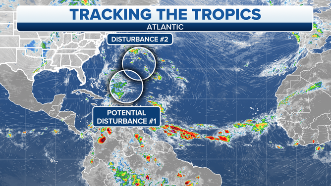
North in the Atlantic, Disturbance #1 has been on the verge of becoming a tropical depression since yesterday. It has a very well-defined circulation, but hostile upper-level winds have prevented thunderstorms from persisting near the center. Today is its last chance, and its odds are diminishing.
The system is heading north into cooler waters and even more hostile upper winds where it is expected to die out by tomorrow.
The system brushed by Bermuda on Monday, but it’s moving away Tuesday, so the effects are diminishing.
Potential Disturbance #2 is a large area of disturbed weather east of the Bahamas related to a large upper-level system and an old cold front. This is the same cold front that brought fall temperatures to the southeastern U.S. days ago.
The computer forecast models predict that a non-tropical low-pressure system will develop east of the Bahamas as the upper-level system gets air spinning down at the surface of the ocean. The persistence of the thunderstorms over the warm Atlantic waters and briefly more conducive upper winds might allow a hybrid system to form offshore of the Bahamas and the southeastern U.S.
If the hybrid system is found to have winds of 40 mph or higher, it would likely be named Subtropical Storm Lisa. Subtropical in this case means a hybrid of tropical and non-tropical.
The National Hurricane Center gives the system a fairly low chance of developing. In any case, the expectation is that anything that develops would stay offshore.
FOX Weather Hurricane Specialist Bryan Norcross has a podcast, Tracking the Tropics with Bryan Norcross, available now on FOX News Audio. You can get it on your device by clicking here.
"spot" - Google News
October 25, 2022 at 08:46PM
https://ift.tt/xEAwUkg
More areas to watch including a familiar spot in the Caribbean - Fox Weather
"spot" - Google News
https://ift.tt/MrUCd9e
https://ift.tt/KhanOzd
Bagikan Berita Ini


0 Response to "More areas to watch including a familiar spot in the Caribbean - Fox Weather"
Post a Comment